Enabling Persistent Maritime Situational Awareness Over Large Ocean Areas
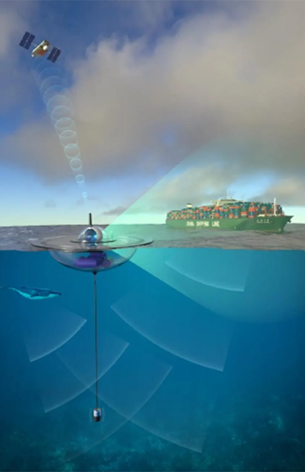
The Ocean of Things (OoT) program seeks to deploy thousands of low-cost, environmentally friendly, intelligent floats that drift as a distributed sensor network.
Each drifter manages a suite of commercially available sensors to collect environmental data such as ocean temperature, sea state, and location as well as activity data about commercial vessels, aircraft, and even marine mammals moving across the ocean.
The floats transmit processed reports when needed via satellite to a government-owned cloud network for storage and real-time analysis. Data from this floating distributed network will support Department of Defense missions as well as public oceanographic research and commercial applications.

This program is now complete
This content is available for reference purposes. This page is no longer maintained.
Resources
Deep Dive
Data
The program has developed cloud-based software and analytic techniques to process float data.
Accurately Modeling Surface Currents
Models exist for subsurface ocean currents and weather activity above the surface, but the air-ocean interface is not a fully understood realm.
Being able to accurately model the ocean’s surface currents could yield a variety of benefits such as more accurately predicting movement of an oil spill, or supporting search and rescue operations for a man overboard or vessel adrift.
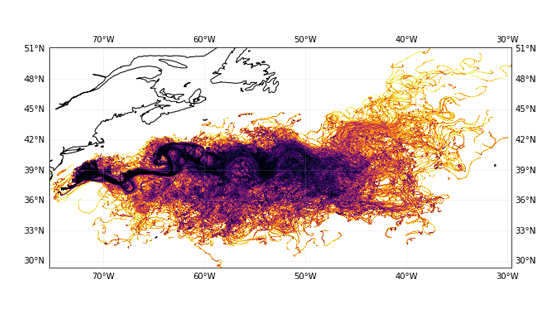
As a part of the Ocean of Things program, DARPA held the Forecasting Floats in Turbulence to spur development of algorithms to better predict where free-drifting floats will travel over time.
Congratulations to our winning teams!
First Place: Second Sight Predictions
Second Place: Deltares
Third Place: Center for Ocean-Atmospheric Prediction Studies
Program Benefits
Ocean of Things passively collects all of its information.
Of the types of information discussed above, one example benefiting marine mammals is acoustic data collected at a fine spatio-temporal scale that may be able to detect, identify and track marine mammals and quantify background noise-scapes.
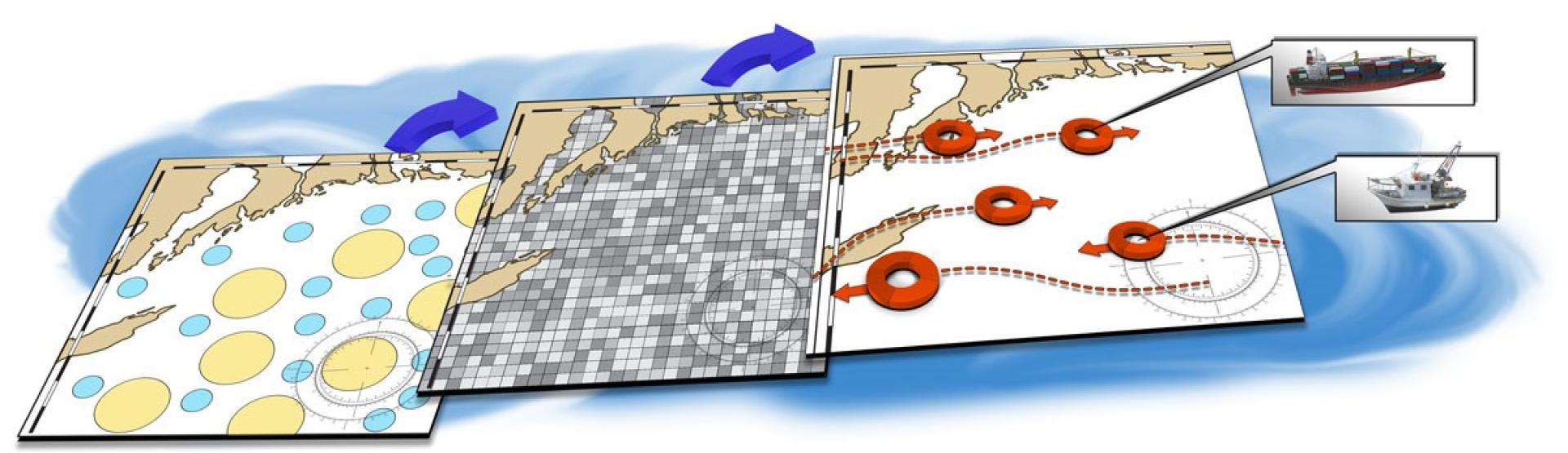
This information can then be used to improve our understanding of marine mammal behavior in regional basins. The program will also develop algorithms to automatically detect, track and identify nearby vessels, as well as the identification of new indicators of anomalous maritime activity such as illegal fishing behaviors.
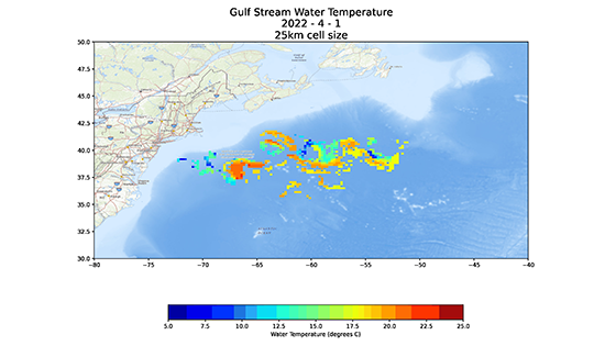
Planned environmental capabilities include measuring sea-surface temperature over a large region, mapped with sufficient density, to better understand ocean currents and mixing. Combined sea surface measurements can be used together with remote sensing data to build more accurate regional models of primary productivity and potential distributions of marine organisms for improved management of marine resources and fisheries.
These in-situ sensor measurements are also critically important for calibration of satellite measurements. For example, field observations improve the accuracy of satellite-derived chlorophyll in-ocean color sensors, linking in-situ measurements to processes within the water column below.
The OoT system incorporates this information and provides users a modern platform to support dynamic, relevant and more efficient ocean management. This paradigm shift away from terrestrial-based management techniques (e.g., quota-based systems tied to stationary marine protected area boundaries) has been proposed in numerous marine sectors but so far has lacked sufficient accessible real-time data about changes in the ocean environment.
With the addition of advanced data analytics, OoT will automate many processes that previously required human analysts.
These papers, published by IEEE in 2022 showcase some of the real impacts by the Ocean of Things program:
- Low-Cost, Intelligent Drifter Fleet for Large-Scale, Distributed Ocean Observation
- In-situ data from two 1500+ sub-mesoscale near-Lagrangian float deployments across 14 different sensor types
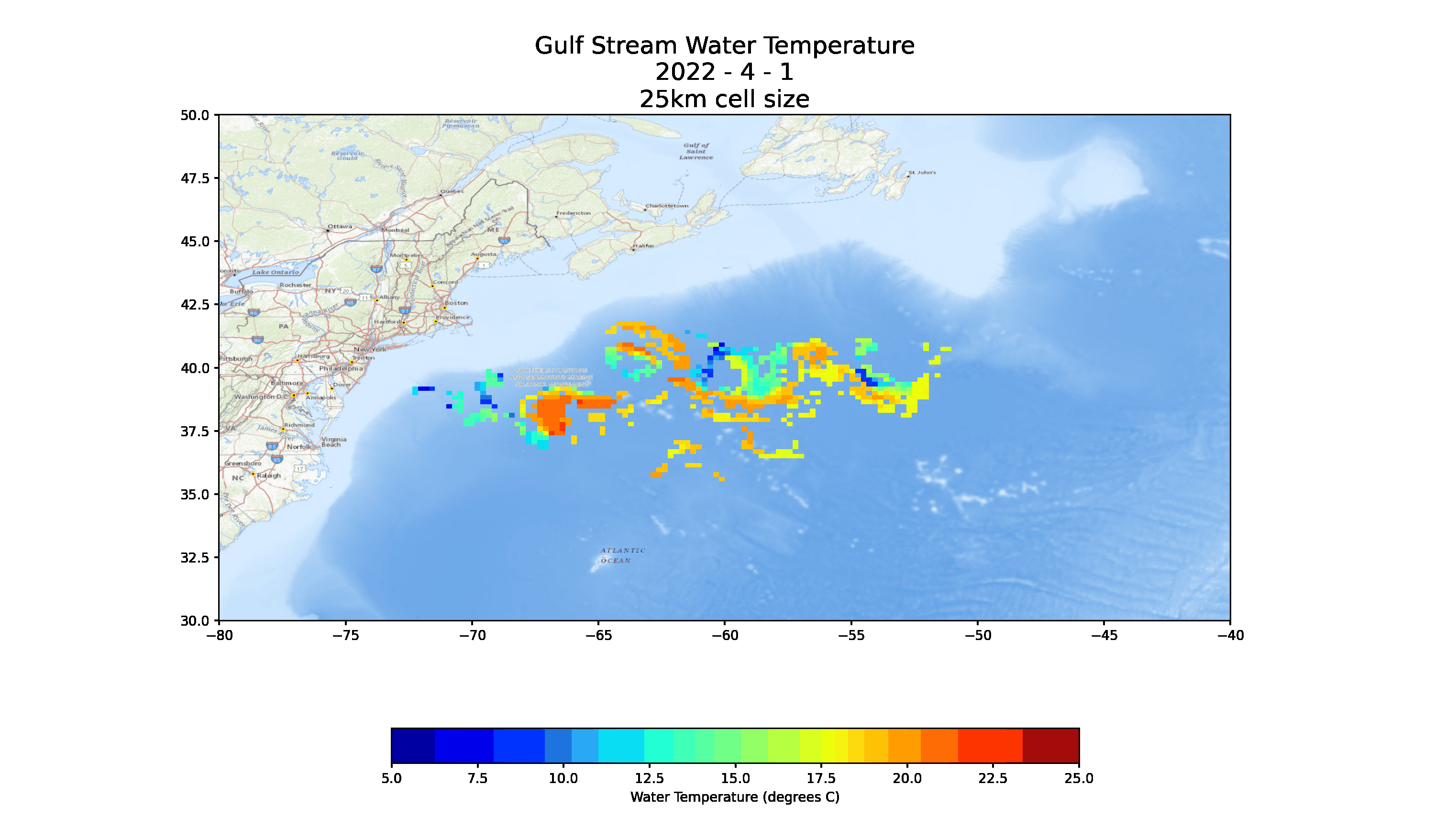
Deployment Locations
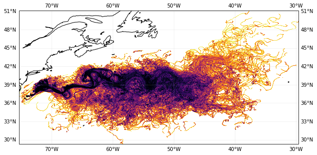
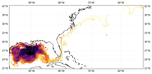
Approximately 1,850 floats were deployed in the Gulf of Mexico in February 2022 and 1,750 floats were deployed in the North Atlantic in March 2022.
The environmental data collected during these deployments provide value to government and researchers studying the loop current, the Gulf Stream, and sub-mesoscale features with in-situ measurements.
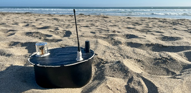
Hardware
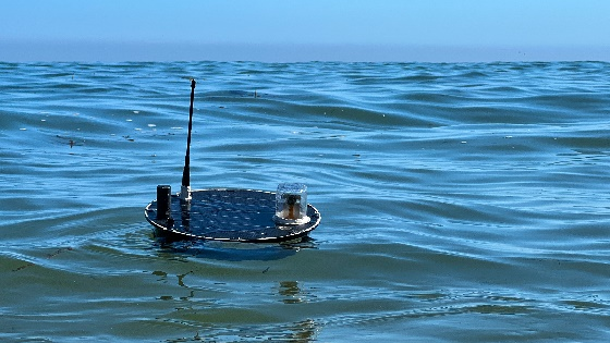
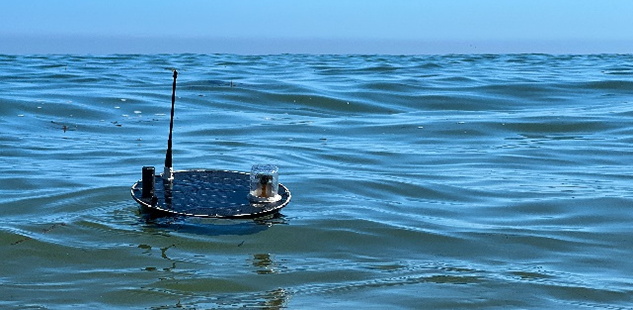
The program developed three types of environmentally compliant drifters to house passive sensors that can survive in harsh maritime environments.
Each float will monitor its surroundings for up to one year before safely scuttling to the ocean floor. The floats are made of biosafe materials, pose no danger to vessels, and comply with all federal laws, regulations, and executive orders related to protection of marine life.
Float Data
The data analytics portion of the Ocean of Things program has developed cloud-based software and analytic techniques to process data collected by floats.
This software can dynamically display float locations, health, and mission performance; process environmental data for oceanographic and meteorological models; automatically detect, track, and identify nearby vessels; and identify new indicators of maritime activity.
Predictive modelling of surface currents and wind within the deployment region informs initial deployment and periodic additions to ensure area coverage.
Explore Environmental Information
Environmental data is now available to download via ERDDAP:
Additional data:
- Location: other
30 days Sofar May 2021 - Location: Atlantic
30 days Sofar Nov. 2021
If You Find a Float
Floats are designed to sink to the bottom as they approach the experiment’s geographic boundary. In the unlikely event a float is found, please follow the steps below to return the float:
- Take a picture of the float and upload it via the barcode on the float label.
- If found at sea, return the float to the ocean. This will enable the float to continue supporting research.
- If found on shore, please contact DARPA at the email address on the float label to facilitate return or disposal.