Competition reveals difficulty in predicting movement of free-floating objects on ocean’s surface
Dec. 13, 2021
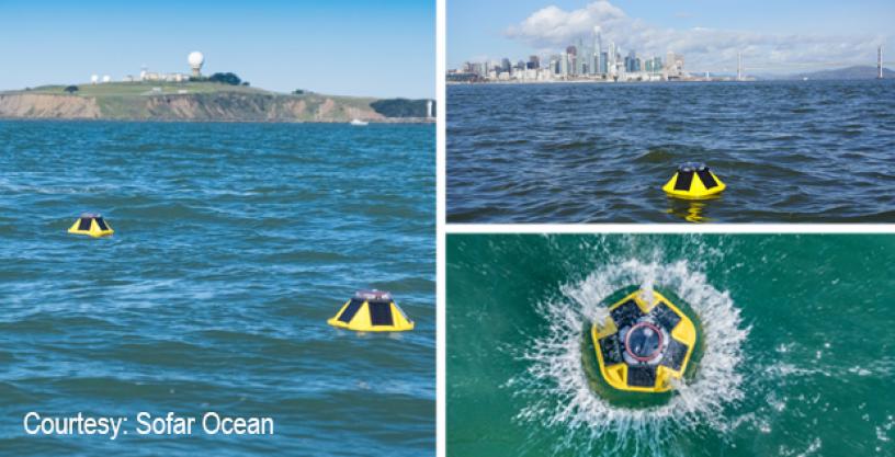
The mystery of knowing where the proverbial message in a bottle thrown overboard in the open sea will eventually wash ashore has not been solved. But DARPA’s recent Forecasting Floats in Turbulence (FFT) challenge took an exploratory first step toward trying to understand the turbulent convergence of wind, waves, and currents on the surface of the ocean – and its effect on objects floating at sea. The competition was part of DARPA’s Ocean of Things program, which uses low-cost distributed drifters for maritime situational awareness.
The goal of the challenge was to spur development of algorithms to better predict where free-drifting floats will travel over time. Competitors developed algorithms or other methods to predict where 90 Sofar Spotter drifters – about the size of a basketball – floating freely in the Atlantic would travel over a 10-day period. Each team received the previous 20 days of location data from the drifters’ GPS coordinates. Using that data, teams attempted to predict where the spotters would travel a week and a half into the future.
Three teams from a field of 32 competitors took top spots, winning $25K, $15K, and $10K, respectively: First place went to Second Sight Predictions with 498 points; Deltares took second with 425 points; and the Center for Ocean-Atmospheric Prediction Studies (COAPS), came in third place with 395 points. Second Sight Predictions was a single-person team, Chris Wasson, a guidance, navigation, and control engineer working on satellite development in southern California.
Points were awarded based on prediction accuracy of drifters’ location in 2-day, 4-day, 6-day, 8-day, and 10-day forecasts. The further out the forecast, the higher the point value for accuracy. For example, a two-day forecast within 16km of the actual float position was worth one point, but a 10-day forecast within 16km was worth 20 points for added difficulty. Lastly, to ensure competitors had strong trajectory models, they would no longer receive points for any drifter prediction that experienced greater than 32km of error for any forecast. So, if a forecast for a particular float was off by 50km on Day 6, but within 1km on Days 8 and 10, they would receive no points for that float because the trajectory was too far off.
Results varied significantly by float and by team: No points were awarded for 8 floats, while Second Sight Predictions and Deltares each predicted a float within 4km on Day 10.
“I’m extremely encouraged by some of the innovative methods demonstrated by our competitors, and equally by the sheer number of competitors who rose to this challenge,” said John Waterston, program manager for the Ocean of Things program in DARPA’s Strategic Technology Office. “Using inexpensive, large scale in-situ drifters is a new way of looking at ocean sensing and addressing the lack of fidelity in current models of the ocean’s surface. We wanted to provide access to this float data and get people excited about approaching the problem in novel ways. The challenge has shown that we’ve just scratched the surface in understanding the complex turbulence at the convergence of air and sea, and we hope to spur further research into making models more accurate.”
Competitors shared insights into what they learned from and how they approached the challenge.
“I was very happy to discover this challenge where the focus was split equally on algorithms and their application to an engineering problem,” Wasson said. “There are still many examples in the challenge float data where the float trajectory disagrees strongly with all available ocean current and wind data at that latitude/longitude. I think this is a strong indication that one of the biggest remaining hurdles in this problem is not in modeling surface effects but in identifying errors in these models, particularly ocean surface current models.”
Second-place team Deltares leveraged their work in hydrodynamic modeling near the coasts and employed a physically-based modeling approach integrated into a forecasting platform.
“We are passionate in improving our understanding of particle movements in ocean and coastal seas,” said Kun Yan from Deltares. “As well as its wide application, e.g. mitigating oil spills, search and rescue operations, determining the trajectory of fish larvae, etc.”
# # #
Media with inquiries should contact DARPA Public Affairs at outreach@darpa.mil
Associated images posted on www.darpa.mil and video posted at www.youtube.com/darpatv may be reused according to the terms of the DARPA User Agreement.
Tweet @darpa