The Challenge | |
|---|---|
| Drones take off with payload, then fly 4 nautical miles (12 laps) | |
| Drones deposit the payload, then fly 1 nautical mile (3 laps) | |
| Drones must finish their circuit within their 30-minute flight window. Each teams gets two flight windows during the competition to post their best score. | |
Dimensions | ||
|---|---|---|
| Flight corridor | 60' x 1,060' | |
| Buffer zone | 20' on all sides | |
| Altitude | 150' high (+/- 50') | |
| Drones that fly outside the buffer zone are subject to penalties | ||
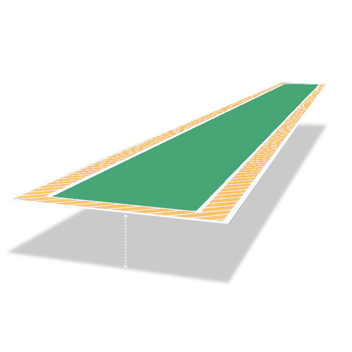
Source: DARPA | Jahyra Catala
We want to revolutionize vertical-lift aviation. And you can be there when it happens. The DARPA Lift Challenge is open to the public Aug. 6-9, 2026, at the National Museum of the US Air Force. | 0:53
The latest in our long history of audacious challenges, the DARPA Lift Challenge aims to revolutionize heavy vertical lift aviation.
Competitors must create an aircraft that is both lightweight and powerful – lifting at least 4x its weight while flying a 5-nautical-mile circuit course.
In a head-to-head, live performance trial, competing teams will fly their novel drone designs. Those with the highest payload-to-weight ratios and novel designs will win $6.5 million in prizes.
But it’s not just a prize competition – it's a catalyst for long-term growth and innovation across the American drone industry. Participants will play a critical role in advancing vertical lift technologies that will have far-reaching benefits for military missions and civilian needs.
Winners were selected based on payload and performance, as well as technical merit, innovation, and potential impact.
Objective category
According to Challenge rules, teams that met or exceeded the challenge goal of a 4:1 ratio would earn the full prize purse for their award level, while those that came in under the target would earn half the prize purse for each place.
| Payload-to-Weight Performance Award | |||
| Position | Team | Payload-to-weight ratio | Prize |
| 1st | AVIDrone, Inc. Columbia, Md. | 3.84:1 | $1,250,000 |
| 2nd | MTech Operations, LLC Sudbury, Mass. | 3.64:1 | $750,000 |
| 3rd | Xtreme Aerial Concepts San Jose, Calif. | 3.45:1 | $500,000 |
Subjective category
Subjective category honorees were selected by a panel of DARPA program managers with deep aviation expertise.
| Most Revolutionary Aerodynamic Design | |
| Team | Prize |
| University of Maryland Autonomous Micro Air Vehicle Team College Park, Md. | $500,000 |
| This team's design blended a tri-rotor into the propulsive design of a propeller-driven rotor by using servos to change blade and motor angles. Their craft takes off and lands like a multi-rotor craft and then transitions to a propeller-driven rotor once airborne. | |
| Most Revolutionary Powertrain Design | |
| Team | Prize |
| Portal Aircraft Company Mansfield, Texas | $500,000 |
| This team created a novel, scalable concept that uses hot or cold turbine exhaust to drive the rotors, replacing driveshafts and mechanical linkages. Their approach could provide higher reliability due to fewer mechanical components. | |
| Most Promising Technology | |
| Team | Prize |
| DefendTex Moab, Utah | $500,000 |
| While this team’s aircraft did not complete a scored run, it achieved the highest ratio in the competition at 9.63 to 1. The aircraft uses string-based support to individual motors to reduce hub structure and overall vehicle weight. The design is simple, easy to deploy, and minimizes disk loading on each propeller. | |
This section outlines the official flight course dimensions, color-coded operational zones, and the mandatory procedures associated with each boundary. All teams are required to understand and adhere to these rules during their scoring attempts.
The flight lane is a defined corridor measuring 100 feet wide by 1,100 feet long. A multi-tiered zone system will be used to provide real-time feedback and enforce safety protocols.
Zone Definitions and Required Actions
Green Zone (Safe Flight Corridor)
- Dimensions: A 60-foot-wide by 1,060-foot-long corridor centered within the flight lane.
- Description: This is the designated safe and optimal flight path. Operations within this zone are considered nominal.
Yellow Zone (Warning Buffer)
- Dimensions: A 20-foot buffer area located along the inside edges of the flight lane.
- Description: Entry into the Yellow Zone indicates that the aircraft is approaching the lane boundary. A visual warning will be triggered on the Remote Pilot in Command (RPIC) display.
- Required Action: None
Red Zone (Run Termination)
- Dimensions: The area beginning 35 feet outside of the primary flight lane boundary.
- Description: Entry into the Red Zone constitutes a boundary excursion and results in the immediate termination of the scoring attempt.
- Required action: The scoring attempt for that run is officially concluded. The pilot must safely maneuver the aircraft back into the lane and return to the starting position. Subject to remaining mission time, the team may refuel, re-weigh, and begin a new attempt.
Black Zone (Geofence Breach)
- Dimensions: The entire area beyond the site's established geofence perimeter (indicated by a dotted line on the RPIC display).
- Description: A Geofence Breach is a critical safety event. It indicates the aircraft has left the designated operational area. The following tiered emergency protocol is mandatory.
Required Action Protocol
- Immediate correction: The pilot's primary and immediate responsibility is to attempt to guide the aircraft back inside the flight box.
- Land immediately: If the aircraft is unresponsive to corrective inputs, the pilot must land the aircraft immediately, regardless of its position.
- Activate kill switch: If the aircraft is unresponsive, cannot be landed safely, and continues to travel away from the operational area, the pilot must activate the kill switch as the final resort to ensure site containment.
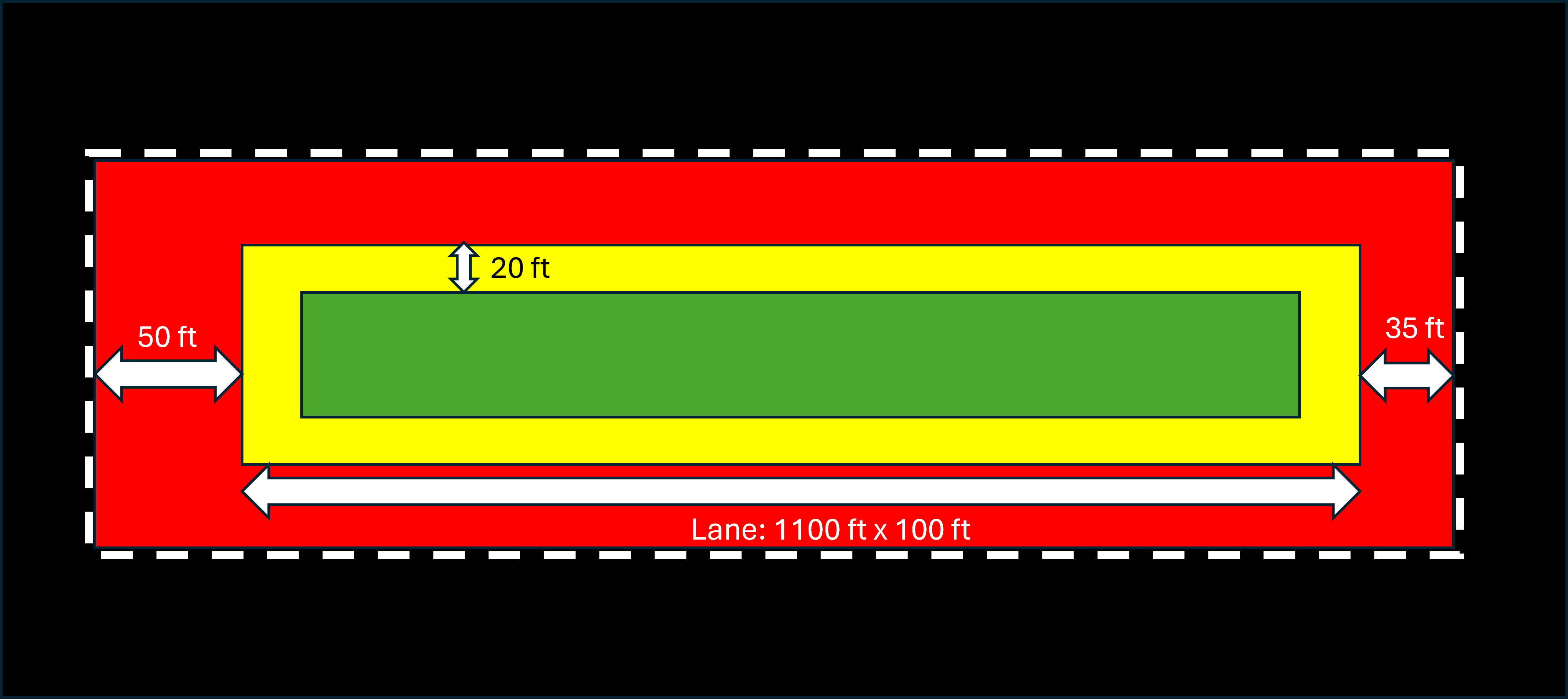
This graphic shows Lift Challenge lane boundaries as described in The Competition Course Section. Source: DARPA
- Categories: Objective
- Subjective
To be eligible to receive prize money, the Lift Challenge requires registrants' Social Security Number (SSN) or Taxpayer Identification Number (TIN). See Rules for additional eligibility requirements.
Objective Categories
Overall Payload-to-Weight Ratio
This is the primary metric, with prizes awarded to first ($2.5M), second ($1.5M), and third ($1M) place.
- Measurement: Payload and aircraft weight in pounds (lbs), as measured by a certified and calibrated scale. The scale must have a resolution of at least 0.1 lbs (0.045 kg).
- Scoring: The primary metric is the maximum payload weight divided by the aircraft weight. In the event of a tie, the team with the fastest time will be declared the winner. Each team will be evaluated based on its ‘most successful’ singular run across all of its attempts. Please note score signifies payload weight (lbs) / aircraft weight (lbs).
- Verification: DARPA representative will weigh the aircraft and payload right before flight.
- Payload requirement: Teams must meet a minimum of 110 lbs payload and follow the course rules for score consideration. The top three teams will receive the full prize award if they are above the 4:1 ratio. If they are below the 4:1 ratio, the team will receive 50% of the prize award. | Read about the winners
Subjective Categories
These categories will be judged by a panel of DARPA experts and will be based on a combination of technical merit, innovation, and potential impact.
- Most Revolutionary Aerodynamic Design ($500,000)
Evaluation Criteria: Novelty of the design, potential for improved performance (e.g., lift, drag, stability), and feasibility of operation.
- Most Revolutionary Powertrain Design ($500,000)
Evaluation Criteria: Novelty of the propulsion system, potential for improved efficiency, reliability, and scalability.
- Most Promising ($500,000)
Evaluation Criteria: Overall potential of the design to meet the needs of customers, considering factors such as cost, performance, scalability, usability, and transition potential.
Eligibility
- Intent to compete: Individuals and teams must attempt to complete the course, high performance and completion of the course is desired but not required to be eligible for this prize category.
Example: You have a novel design, but crashed on takeoff.
- A team who wins an objective category can also be eligible for one or more subjective categories.| Read about the winners
Broadcast team
This broadcast portion, featuring the following hosts, coincided with the public access days during the final four days of competition.
The Lift Challenge broadcast team guided viewers through the competition: veteran sports broadcaster Todd Harris as lead commentator, drone educator and content creator Joshua Bardwell as analyst, and professional drone racing pilot Elena Buenrostro as field reporter.
Together, they led viewers as teams attempt to achieve unprecedented payload-to-weight ratios and compete for up to $6.5 million in prizes.

Event Commentator
Todd Harris
Harris brings decades of experience calling live sporting events for national television audiences. A longtime NBC Sports commentator, he is widely recognized for his work covering Olympic and action sports and for translating complex athletic competitions into compelling stories for viewers.

Analyst
Joshua Bardwell
Bardwell is an educator, content creator, and product reviewer who has helped make drone flight more accessible. He established his self-titled YouTube channel as a resource for beginners and veteran pilots alike. As an analyst, he will provide insight into aircraft design, flight performance, and the technical innovations competitors bring to the Challenge.

Field Reporter
Elena Buenrostro
A licensed commercial drone pilot and the Founder and CEO of Women Who Drone, Buenrostro also judges drone film festivals and works with the Federal Aviation Administration, DroneDeploy, Columbia University, Vaughn College of Aeronautics and Technology, and Google. As the field reporter, she’ll report from the competition field and interview competitors.
Follow #DARPALiftChallenge



What's Your RatioTM